History
Introduction
adapted from Pate and Wilkins 1980
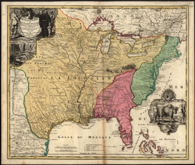
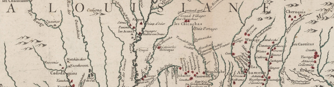
During the 1700s the western hemisphere’s three greatest empires looked to the New World as an untapped source of wealth and power. Through trade, colonization, and military dominance, France, England, and Spain struggled to gain a foothold in the wilds of America. By 1700, England was well-established along the Atlantic coast, and Spain held tightly to La Florida. The French controlled Canada, and a vast portion of interior North America that they named La Louisiane after Louis XIV, the Sun King. The French established forts throughout colonial Louisiane to protect their settlements, strengthen Indian alliances, and hinder English encroachment. There is perhaps no other place on the mainland of North America where colonial powers came so close together than at Fort Tombecbe, situated on a bluff overlooking the Tombigbee River.
French Construction and Occupation, 1736-1763
Fort Tombecbe was strategically built in an area claimed both by France and England and was established to prevent the English from gaining a foothold there. The Anglo-French rivalry often involved the Indians of the area, who engaged in alliances and treaties with both sides at various times. Tombecbe became the major French outpost and trade depot among the Choctaw, the largest Indian group in the colony. In 1736, the governor of La Louisiane, Sieur de Bienville, ordered construction of the fort to serve as a supply depot and starting point for his vengeful military expedition against the English-allied Chickasaw Indians.

In May of that year, Bienville gathered at Tombecbe an army of 600 Frenchmen, including professional soldiers, Swiss mercenaries, volunteers, militia, and a company of 45 free Africans. They joined forces with nearly 600 Choctaw warriors before launching a failed attack on the Chickasaw at the Battle of Ackia, near present-day Tupelo, Mississippi. Though soundly defeated, Bienville ordered that a garrison of men maintain Fort Tombecbe as a diplomatic “listening post” for the French in their continued efforts to stop English intrusions into the area and as a trading post for the eastern Choctaws.
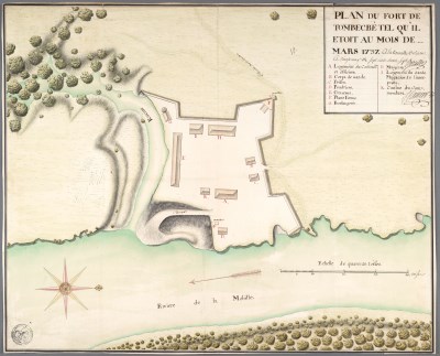
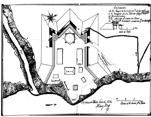
Construction of the fort was completed in 1737. Bordered on the east by the 80-foot river bluff and on the south by a deep ravine, the fort had excellent natural defenses. It was also enclosed by a ten-foot high stockade of cedar posts and had three thirteen-foot high gates. The primary buildings within included: the officer’s quarters, the garrison barracks, the powder magazine, the storehouse, the guardhouse and prison, a bake house, interpreter’s hut, and officer’s kitchen. Secondary buildings included small sheds and privies. At least one trader’s hut was located outside the walls of the fort, and a cemetery likely was established nearby. The humid climate had taken its toll by the 1750’s, and the fort’s stockade and buildings underwent major repairs.
Duty at the isolated post in the wilderness constituted a hardship tour, and troops were rotated yearly. Supply boats from Mobile were inconsistent, and there were shortages of flour, clothes, and goods for trading with the Indians. The Choctaw regularly complained that the French did not have enough trade goods, which left the French vulnerable to being undermined by well-supplied English traders in the region. The ability of the French to maintain La Louisiane depended largely on their alliances with native peoples. At Tombecbe, their friendship with the Choctaw was critical for protection, as well as food, deer skins, and items necessary for everyday living. Historical records indicate that Choctaw women were important contributors to some of the daily domestic tasks at the fort.
When the French chose White Rock Bluff for their fort, the small creek to the north was called Itomba-igabee Creek. Historical tradition and some documents indicate that this means “box maker’s creek” in the Choctaw language, so named after a Choctaw man who lived there and made coffins from the red cedar that is abundant in the area. In his memoirs from the period, Dumont de Montigny, says "...the name 'Tombecbe' that is given to this place signifies, in the Choctaw language, 'land of pottery.'" Though the meaning and origins of Itomba-igabee are uncertain, the creek did lend its name to the French fort, as “Tombecbe,” and to the entire Tombigbee River. Over the years, the fort’s name has been spelled as Tombecbee, Tombeckbee,Tombecbé, and Tombecbe. The latter spelling is used here to reflect the one most frequently used. It is pronounced “tom-BEK-bee.”
Tombecbe played a vital role in the Choctaw Civil War of 1746-1750 by supplying pro-French Choctaws with arms and supplies against the pro-English faction. The treaty ending this war was negotiated and signed at the fort. By the early 1760’s, with the French and Indian War going badly for France, the political situation in the lower colony deteriorated. When the Treaty of Paris was signed in 1763, France ceded all of La Louisiane, except for New Orleans, to the English crown.
The English Occupation, 1763-1768
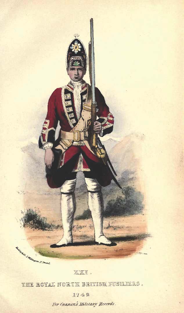
English troops and officers sailed into Mobile Bay in October 1763 and a small group was quickly dispatched up the Tombigbee River to take possession of Fort Tombecbe. When they reached it on November 22, they were greeted by a garrison of fifteen to twenty men and a small group of other residents. The British commander described the area around the fort as having been cleared for two miles and that the opposite bank of the river was cleared for nearly one mile. The open terrain seemed to give the English confidence that they would not be surprised by any hostile attackers.
For the next several years, while the post commander struggled with the ever-present problems of frontier command, the British abandoned Tombecbe, needing additional forces for the opening of the British West Florida territory along the Mississippi River. The fort’s British garrison quietly withdrew from Tombecbe in October of 1764, leaving it to Jeremiah Terry, a trader among the Choctaws.
By 1766, due to renewed hostilities between the Choctaws and Creeks, British military authorities again garrisoned Tombecbe, this time with a lieutenant and twenty men. For the next year, Tombecbe and the surrounding countryside were the scene of bloody confrontations between Choctaw and Creek warriors. Following a call for peace between the two tribes in 1768, plans were again made for a military evacuation of the post, for the British presence at Tombecbe was never intended to be permanent. The end of the Choctaw-Creek War in 1770 brought increased trade and traffic to the traders stationed at Tombecbe.
Fort Tombecbe, as occupied by the French and English, had fallen into ruins by 1772, and more than two decades passed before the white bluffs of Tombecbe would hold another European military post.
The Spanish Occupation, 1794-1797
In the late 18th century, while Spanish and American diplomats argued over a possible boundary in Gulf country, a frontier post was once again established on the old site of Fort Tombecbe. The Spanish raised their flag over territory that was claimed by the young United States. This small outpost on the northernmost fringe of a great Spanish empire became a significant part of a defense system designed to protect the Spanish provinces of Louisiana and West Florida. Tombecbe became the unofficial capital of an Indian buffer state created by Spanish officials to stop the expansion of the American frontier. In 1792, urged by Cherokee Chief Bloody Fellow, the Spanish king agreed to establish Spanish military posts at Muscle Shoals in North Alabama and at Tombecbe.
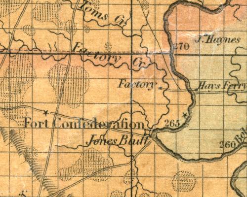
With the signing of the Treaty of Boufouca, the Choctaws ceded twenty-five acres of land at the old French Tombecbe site for the construction of a Spanish fort and trading post. It was named Fort Confederation in honor of the agreements between the Europeans and the Indians, and by its completion in 1794,
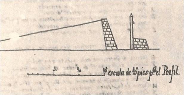
the new post was attracting a large Indian delegation. The Spanish fort was much different from its predecessor. The type of wooden stockade wall that had been erected by the French offered adequate protection from musket balls and arrow points.The Spanish, however, needed protection from potential artillery fire from American cannons. In response to this threat, they constructed a crown-shaped earthwork with a steep exterior slope. An interior wooden palisade added additional protection. Confederation contained a two-story, wooden blockhouse, officers’ quarters, commandants’ quarters and kitchen, the troops’ quarters and kitchen, a prison, powder magazine, and latrines.
The American Period
By 1795, the post was threatened by the outbreak of hostilities between the Chicksaw and Creek, and by 1797, the United States and Spain both claimed the fort. The Spanish occupied Fort Confederation for less than three years before it again became the focus of an international treaty. The avoid war with the United States, Spain signed a treaty ceding all land north of the 31st parallel, which included the Tombecbe site.
The Spanish retreat from the upper Tombigbee River Valley brought an end to Alabama’s colonial period, but the Tombigbee region played yet another role. In 1815, the United States established the Choctaw Trading House near the old Fort Confederation. The trading house, also known as a “factory” at that time, was established by George Strother Gaines, who had successfully served as manager, or factor, of the trading house at Fort St. Stephens in present-day Washington County. Gaines relocated the trading house further up the Tombigbee to be nearer to the Choctaw villages, in part to compensate the Choctaws for their role in the Creek Wars (1813-1814), and to better serve the increasing numbers of settlers in the region. The trading house received and processed deer skins, sold agricultural implements, tools, and other goods. It was visited by many important historical figures and was the site of a significant treaty with the Choctaws, by which they ceded a portion of land east of the Tombigbee River. The trading house remained active until 1823 and served thousands of settlers who poured into the new State of Alabama.